Introduction
Petroleum exploration still relies mainly on 3D seismic to discover hydrocarbon accumulations in prolific basins throughout the world. This technique uses large assets i.e. vessel, streamers, guns and compressors to achieve the desired results. However in recent years, geochemistry/seabed sampling; gravity; electromagnetic; and remote sensing are used as alternative screening methods to aid in petroleum exploration activities. High Resolution Seismic and Hydrography screening over large acreage for active petroleum system indicators can also be a cost effective and efficient alternative screening tool to the 3D seismic.
Extended Petroleum System
An active petroleum system consists of a source rock, reservoir rocks, migration, traps and seal rocks. The effectiveness of these components are governed by processes of generation, migration, accumulation and preservation of hydrocarbons.
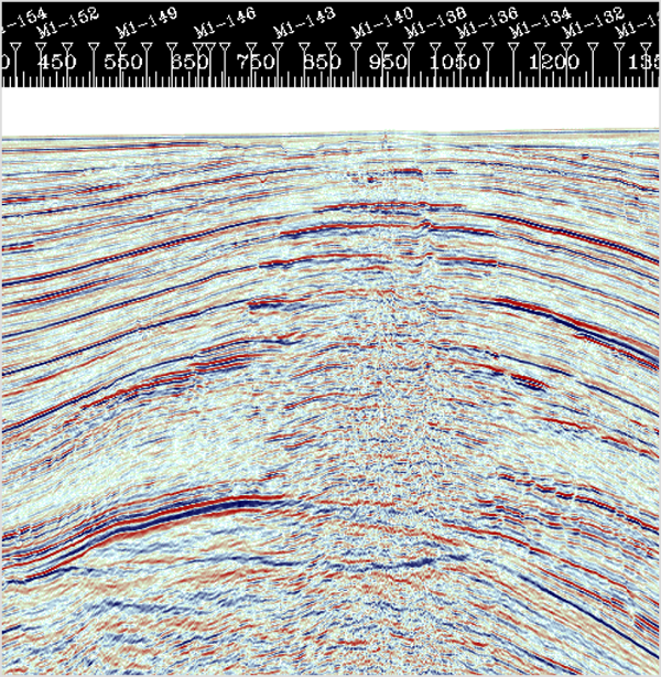
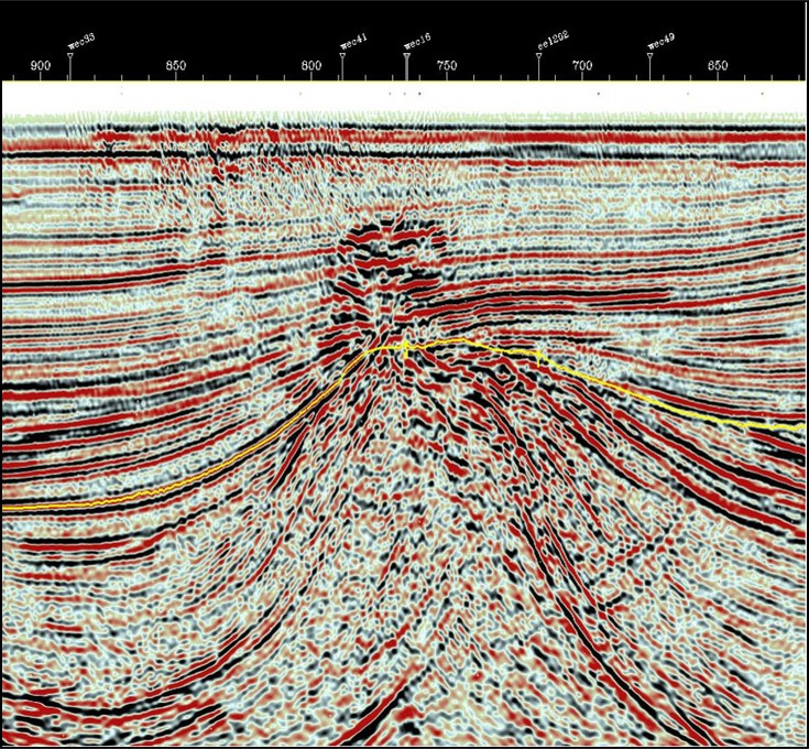
However, more often than not these petroleum systems leak through buoyancy driven forces along faults and fluid expulsion features or along major hydrodynamic fluid flow pathways and lead to shallow hydrocarbon accumulation and seeps
Processes controlling hydrocarbon migration are assumed to be dominantly vertical, thus, causing a surface pattern reflective of a subsurface petroleum accumulation. Abrams et al., 2001; and Abrams 2005 concur that the presence of near-surface migrated hydrocarbons can provide strong evidence of an active petroleum system. The objective of HRSH screening for exploration is to identify these near surface patterns and shallow accumulations that are indicative of an active petroleum system prior to 3D exploration survey.
High resolution seismic and hydrography methods are proven effective in depicting near surface hydrocarbons accumulations and seeps. The method uses relatively smaller assets including various acoustic equipment with different frequencies to collect seabed surface images and subseabed seismic data up to 2 – 3 seconds two way time.
The morphological features associated with an active petroleum system are gas vents, pockmarks, pockmark clusters, seabed depression and corals. These could be easily depicted on side scan sonar, sub bottom profiler, multibeam echo sounder and single beam echo sounder. Seismically, the presence of migrated and accumulated hydrocarbons below seabed are divulged by bright spots, gas chimneys, acoustic blanking, amplitude loss, pull down effect and phase reversal. The high resolution seismic effectively and consistently images these seismic attributes.
In South East Asia, after decades of HRSH data collection and analyses, an active petroleum system would present the following near surface evidences:
- Shallow zone anomalies with 5 direct hydrocarbons indicators
- Fault segments acting as efficient conduits for hydrocarbon migration
- Seabed crater or depression just above shallow anomalies
- Development of coral within seabed depression
- Ubiquitous pockmarks and pockmark clusters
- Gas venting
The High Resolution Seismic and Hydrography identification and mapping of near surface petroleum systems direct indicators provides a cost effective screening tool for reduction of hydrocarbon exploration risks and offers various advantages:
- Identifies active petroleum system direct indicators
- Better understanding of local geology and structure
- Reduction of 3D data acquisition acreage
- Targeted and focused seabed sampling and geochemistry
- Geohazards identification and mapping
- No delay in drilling locations section
- Provides data for geotechnical investigation
- Allows earlier FEED design especially for platforms/FPSO
- 30% cost reduction on 3D data acquisition
- 80% cost reduction on geohazards site surveys